Skip to content

A Safer Future, Sooner

In an emergency, what responders know, and how quickly they know it, can make all the difference.

The Tallahassee-Leon County Consolidated Dispatch Agency (CDA) is developing a Drones as First Responders (DFR) program to provide real-time information in response to certain 9-1-1 calls.

When an eligible emergency is reported, a drone may be deployed as part of the response. The aerial view can help public-safety personnel better understand conditions at the scene before or while police officers, firefighters, paramedics and other responders arrive.

By integrating drone technology into the emergency communications process, CDA can help responding agencies make faster, better-informed decisions.

How DFR Works

DFR uses remotely operated uncrewed aircraft systems to provide authorized public-safety personnel with an aerial view of selected incidents.

A drone may be deployed when:

  1. An incident is reported through 9-1-1.
  2. Emergency communications personnel assess the call.
  3. The incident meets established deployment criteria.

When deployed, a drone can provide real-time information about:

  • Scene conditions
  • Potential hazards
  • Roadway obstructions
  • Traffic conditions
  • Other circumstances that may affect the response

This information can help emergency communications personnel and field responders make better-informed decisions about resources, access, responder safety and incident coordination.

DFR does not replace police officers, firefighters, paramedics, 9-1-1 professionals or the judgment of the people responding to an emergency.

It gives them another set of eyes when seconds matter.

Safe Streets and Roads for All

A $5.8 Million Federal Investment in Safer Roads

The Tallahassee-Leon County Consolidated Dispatch Agency (CDA) was awarded a $5.8 million Safe Streets and Roads for All (SS4A) Implementation Grant from the U.S. Department of Transportation to support a $7.25 million regional roadway-safety initiative.

The project—NextGen Emergency Response: Integrated Drone and Tow Technologies for Safer Streets in Tallahassee-Leon County—brings together Drones as First Responders (DFR) and real-time tow-management technology as part of a coordinated approach to roadway incidents.

The federal Safe Streets and Roads for All program supports local efforts to prevent roadway fatalities and serious injuries. CDA’s project focuses on a critical part of roadway safety that begins when someone calls 9-1-1: what happens after a crash occurs.

From 9-1-1 Call to Roadway Clearance

A serious crash creates more than the initial emergency.

Blocked lanes, congestion, approaching traffic, responders working in or near the roadway, and delays in clearing a scene can create additional risk long after the initial collision.

CDA’s SS4A project is designed to strengthen the response from the first call for help through the safe clearance of the roadway.

The Connected Response

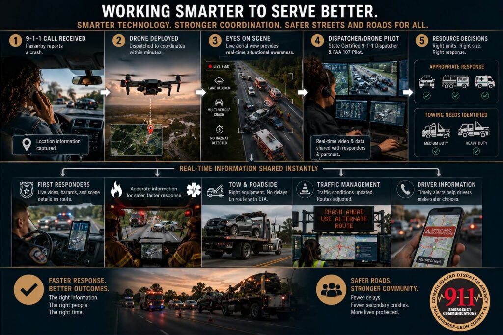
9-1-1 call received → DFR situational awareness → Emergency response → Real-time tow coordination → Roadway clearance

Through this coordinated approach, the project is designed to support:

  • Earlier situational awareness — DFR can help identify crash conditions, hazards, lane blockages and other important scene information.
  • Better-informed emergency response — Responding agencies can receive useful information earlier as they make decisions about resources, access and scene safety.
  • Real-time tow coordination — Integrated technology can help appropriate towing resources reach incidents and begin roadway clearance more efficiently.
  • Reduced roadway exposure — More efficient incident management can help reduce the time responders and others spend working in hazardous roadway environments.
  • Faster roadway restoration — Clearing incidents more efficiently can help restore traffic flow and reduce the conditions that contribute to secondary crashes.

Together, these technologies create a more connected response—from the first 9-1-1 call through the safe clearance of the roadway.

Technology With a Purpose

Innovation matters only when it improves service to people.

For CDA, DFR and the technology supported through SS4A are not about using technology simply because it exists. They are about responsibly using new capabilities to help answer critical questions sooner:

What is happening?

What are the hazards?

What resources are needed?

How can responders approach safely?

How can we help restore the roadway as efficiently as possible?

Better information supports better decisions. During an emergency, getting that information sooner can make all the difference.

Safety, Privacy & Responsible Use

Public trust is essential.

CDA is committed to implementing DFR responsibly, transparently and in accordance with applicable federal aviation requirements, public-safety policies and established operational procedures.

DFR is an emergency-response resource deployed in response to qualifying 9-1-1 calls—not for routine or random surveillance.

Program policies will establish when drones may be deployed, who is authorized to operate the systems and access information, how information may be used, and how applicable records requirements are addressed.

As the program develops, CDA will use this page to provide appropriate public information about program operations, policies, safeguards, updates and performance measures.

Partnership in Action

Safer roads and effective emergency response are shared responsibilities.

The SS4A initiative builds upon Tallahassee-Leon County’s established partnerships among CDA, local government, law enforcement, fire, emergency medical services, transportation partners and others who share a role in public safety.

CDA’s position at the center of the region’s emergency communications system creates an opportunity to connect those partners with emerging technology as part of one coordinated response.

Why CDA?

Every emergency response begins with information.

As the consolidated emergency communications center for Tallahassee and Leon County, CDA connects the public with law enforcement, fire and emergency medical services. CDA also helps coordinate the multi-agency response that follows.

DFR expands that communications mission by adding real-time visual information to the information gathered through 9-1-1 calls and responder updates.

Traditionally, 9-1-1 professionals develop an understanding of an incident from information provided by callers and responding units. DFR can add an aerial view of the scene, helping create a clearer operating picture and allowing critical information to be shared with responding agencies sooner.

From 9-1-1 Call to Response

9-1-1 call received → Incident assessed → Drone deployed when appropriate → Real-time information gathered → Information shared with responders

The goal is simple: get useful information to the people who need it as early as possible.

A Tool to Support Safer Responses

DFR is designed to support the people who respond to emergencies not replace them.

By providing information before or during the initial response, DFR may help responding agencies better understand what they are encountering, identify potential hazards and coordinate resources more effectively.

The result is a safer, more informed response for emergency personnel and the community.